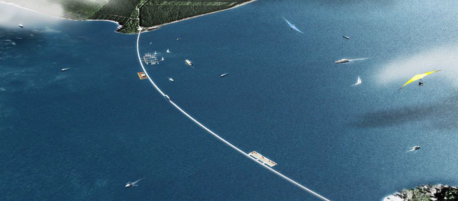
Project 11: Floating pontoon on Lake SedlitzGoing 1000m over water |
|||||
|
Flooding of the Lake Sedlitz will not be completed until 2015, by which time the water level will have risen by eight metres. Today, the lake is already a fascinating site thanks to its banks, little forests and «Kippenrippen« or ridges formed by mine dumps – soon to be lost, but rising from the water as islands for a short time yet. A floating walkway across the growing lake will allow pedestrians and cyclists to experience the site’s transition from an open-cast mine to a lake. |
|||||
INITIAL SITUATIONAlthough lignite mining at Sedlitz ended in 1980 and the rising groundwater had already created a large lake, additional flooding began in 2005. By then, a unique »transitional landscape« had developed in the future Lake Sedlitz area, with large breeding colonies of gulls on the sandy islands, wide reed beds in the shallows and wild-growing birches, and other fast-growing trees on the banks. But this man-made idyll is only a brief moment in time. Every year, the water level rises – and since artificial flooding began, it has been rising faster. |
|||||
THE PROJECT’S PROGRESSSeveral temporary and permanent IBA projects in the Lake Sedlitz area allow people to experience the unique charm of this »temporary landscape« – thereby drawing their attention to the huge changes and fu¬ture potential in Lusatia. A semicircular route ideal for cyclists has already been created along its east and south banks. For years, the IBA has been trying to build a floating pontoon stretching 1,000 metres from the end of the Sedlitz peninsula to the opposite bank to fill a gap in the Lusatian lakes’ route network for cyclists and pedestrians and allow direct access to the Lusatian Lake Land landmark from Sedlitz. |
|||||
FUTURE PROSPECTSThe pontoon should float and rise with the water level, allowing it to be built before flooding concludes in 2015 – as soon as the last technical issues have been resolved. This time frame will also take advantage of the transitional landscape’s special charm. The pontoon is a suitable basis for further tourism development in the area. A business will operate the pontoon, rent out mooring space, and organise events. The master plan for the Sedlitz peninsula includes – among other things – a waterskiing facility, a youth hostel, and a fire service rescue and training centre. |
|||||
Planned locationOn Sorno Canal near the landmark Our partnersMinisterium für Infrastruktur und Landwirtschaft des Landes Brandenburg |
|||||
| go back | |||||
last update: 1/26/2017 13:13 |
|||||